Māruawai · Southland · 46.1° S

A river
runs through
it.

This is Gore — shaped by water, whisky, wool, song and a very large trout.

Before the survey lines

Māruawai

A valley of water.

Long before there was a town called Gore, this place was known to southern Māori as Māruawai — “valley of water”. The Mataura was the constant: a route, a resource and the living line through the land.

THE RIVERMatauraStill runs through the heart of town
The Mataura River seen from the road bridge at Gore
THE LIVING LINEMataura River at GorePhotograph: AlasdairW · CC BY-SA 3.0.

New arrivals

1855

Boots in the tussock.

The first Scottish settlers arrived. Farms began reshaping the tussock, bush and wetlands, while the river ford became a natural meeting point for people moving across Southland.

“You can build a town beside a river. But the river still chooses the route.”
A later nineteenth-century South Island settler family outside their homestead
A SETTLER LIFEA South Island homestead familyRepresentative later-19th-century image—not Gore’s unnamed 1855 arrivals. Public domain.

A place gets a name

1862

Gore, on paper.

The town site was surveyed. Daniel Morton opened Long Ford House for travellers, with beds, stables and something to drink. The settlement was named for Governor Thomas Gore Browne.

Field note № 12Gore Town Survey1862
N GORE MATAURA RIVER Long Ford
12 sections laid out around the old bullock tracksNot to scale
Thomas Gore Browne in formal military uniform
THE NAMESAKEThomas Gore BrowneGovernor of New Zealand, 1855–61. Portrait published 1896. Public domain · State Library of Tasmania.

Making it official

1885

A borough is born.

Gore became a borough. By then, agriculture and industry were gathering pace — the oat and grain mill had opened in 1877, and the town was ready for a fast-growing 1890s.

23years from survey to borough
1river making it all possible
Historic black-and-white photograph of Gore Railway Station
GORE ON THE MOVEThe railway station, c. 1887–1915Archives New Zealand · CC BY-SA 2.0.

Look up

1914

Southland takes flight.

On 20 February, J. W. H. Scotland flew a Caudron biplane from Invercargill to Gore — New Zealand’s first cross-country flight. The future arrived from above.

INVERCARGILL → 65 KM → GORE

Archival drawing of J. W. H. Scotland's Caudron biplane
THE MACHINEScotland’s second CaudronDrawn by John Hood Alexander · Archives New Zealand · CC BY-SA 2.0.

The good years

1945—76

Gore gets busy.

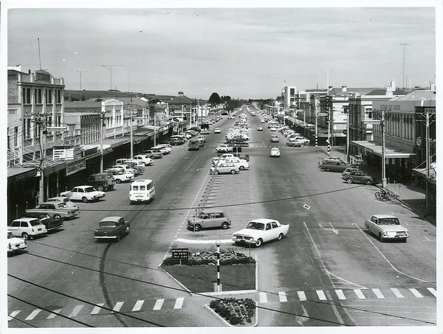
Three prosperous post-war decades brought people, shops and confidence. By the 1960s, Gore was reputed to have New Zealand’s highest retail turnover per person.

OPENMAIN STREETthe south comes to town
Gore Main Street looking south in September 1966
RETAIL HEARTMain Street, September 1966Photographer: Mr Neill · Archives New Zealand · CC BY 2.0.

A wider district

1989

Town meets country.

Gore and Mataura boroughs joined with part of Southland County to form Gore District — 1,251 square kilometres of towns, farms, rivers and famously rolling southern country.

1,251km² of Gore District
Map locating Gore District within New Zealand's South Island
TOWN + COUNTRYGore DistrictLocation map by JaumeBG · CC0.

The story keeps moving

Meet you
by the river.

Explore Gore